
The Remote Sensing and Geoinformatics Laboratory GEOSYSTEMS Polska was registered as a limited liability company in June 1995. Since then, we have been one of the leading providers of geospatial solutions in Poland.
Our key competence is broadly understood spatial information, technologies for its acquisition, processing, analysis and presentation. We carry out research, development and implementation of GIS projects in the field of industry applications of remote sensing, photogrammetry and GIS geographic information systems.
During nearly 30 years of our activity, we have completed a number of pioneering geoinformatics, remote sensing, photogrammetric and cartographic projects.
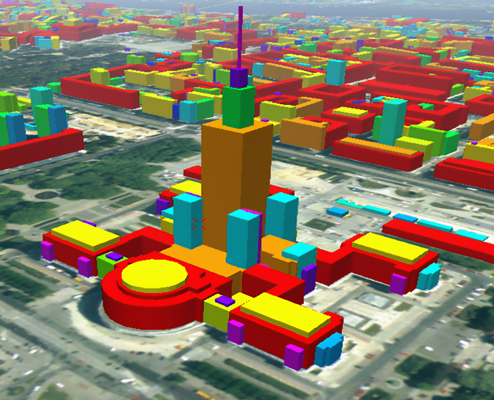
Since the mid-1990s, we have been providing precise data obtained remotely from aerial and satellite data on the topography, type and characteristics of its use and coverage (three-dimensional city models). Our clients included: all telecommunications companies operating in the country, and the data developed by us contributes to the development of new generations of mobile telephony networks and thus to a significant increase in the quality of these services.
In the new millennium, we build databases and implement advanced GIS projects
The company creates a constantly expanded and updated high-quality geospatial database based on satellite and aerial photos (including field research), which allows participation in the most interesting research and development projects.
This database was used in the company’s research on the geographical environment (e.g. European project JRS/EEA MARS MERA/1998, EKOPOL/1999, Spatial Information System for Agricultural Production Space/2000, flood monitoring in Poland/2007, ESA PECS-GMES project FM/2009).
It was also an important component of the interactive city and region maps/models we published and was used in flight simulators and other products intended for a wide audience.
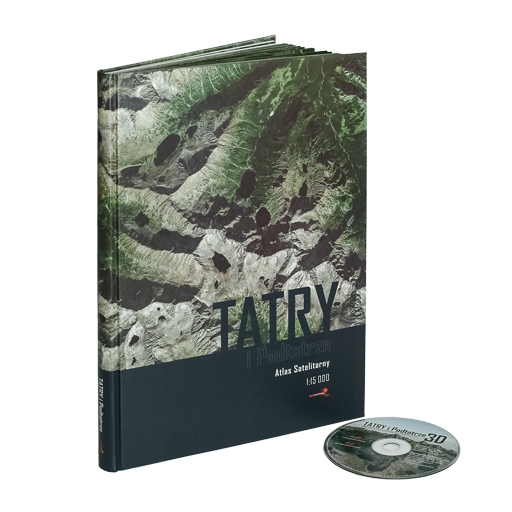
Although our company has never issued printed maps, we made one exception. In 2005, to commemorate our 10th anniversary, we developed and published, using our own resources, the first satellite atlas of the Tatra Mountains and Podtatra 1:15000 in Poland.
The monumental atlas with the attached interactive 3D application is still the most accurate image and the most extensive nomenclature of the Podhale and Tatra region. It was published in an edition of 3000 copies.
We are conquering the satellite navigation market
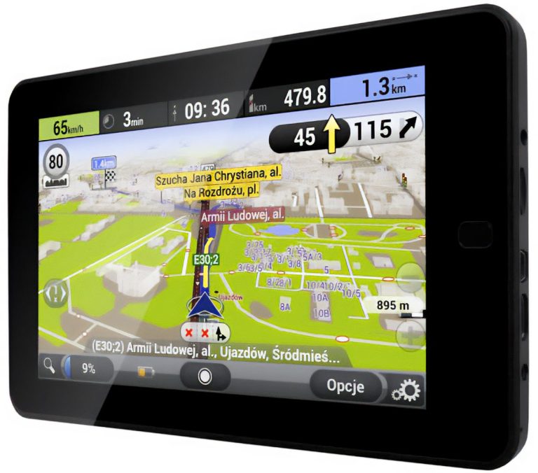
Our greatest success was the development, in cooperation with Aqurat LLC a product known as AutoMapa®. This pioneering GPS navigation system was released back in 2003, long before the era of smartphones. Despite numerous competing products, it remained the most popular in the country for a long time, enjoying high recognition due to the accuracy and timeliness of data. The combined effort of GEOSYSTEMS Polska, Aqurat and Indigo LLC. it also resulted in the creation of one of the leading map services in Poland, Targeo.pl, and its numerous thematic applications (vehicle monitoring, other location services, including those used by all national rescue services).
We provide satellite imagery and processing technologies
From the beginning of our activity, we have been a distributor of satellite data offered by various operators (including ESA, SpotImage, IRS, Cartosat, RADARSAT), as well as a distributor and technological partner of leading producers of geoinformatics software intended for the processing and analysis of image data: ERDAS®, Leica Geosystems®, Intergraph®, HEXAGON®, Trimble® eCognition.
GEOSYSTEMS Poland today
Our current activity is still GIS projects, in particular the implementation of research and development projects. We also focus on the possibilities offered by various types of unmanned aerial vehicles (UAVs) in remote sensing. The latest project we are implementing is the development of a multispectral imaging system and its integration with the tethered aerostat platform (GeoBalloon).
The most important GIS projects implemented by GEOSYSTEMS Polska
Phare MERA Land Degradation Mapping (1995-1997): assessment of soil degradation and erosion in Poland. The aim of the project was to develop and apply coherent methods for collecting and analyzing data from combined remote sensing and cartographic sources to assess, model and map soil erosion processes. (more info).
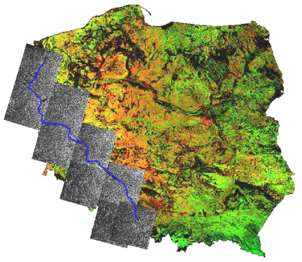
Flood wave monitoring on the Odra River (1997): a project involving “intervention” processing of satellite radar images from the ERS-2 SAR satellite.
Spatial Information System for Agricultural Production Space (APS, 2000): KBN PBZ 17-08 project covering the development of the basis for an IT system for collecting, processing and sharing data and spatial information enabling the valorization of APS and related rural areas. It was based on the development and implementation of quick and reliable methods for assessing the quality of individual elements of the natural and socio-economic environment related to APS, with particular emphasis on methods for assessing the condition of plants enabling forecasts of yields of main agricultural crops. A methodology was developed to widely share RPP valorization indicators in numerical form and the condition of individual environmental elements, with an indication of areas subject to degradation. (see publication).
Cartosat-1 satellite data quality assessment (2008): The Indian Space Agency’s research program focused on verifying the geometric and interpretive quality of images acquired by Cartosat-1, a stereoscopic optical sensor of an Earth-observing satellite in sun-synchronous orbit. The satellite was built, launched and maintained by the Indian Space Research Organization. Verification was performed using a stereo pair of images for a test center located in Poland. The research team included engineers from GEOSYSTEMS Polska and scientists from the Military University of Technology in Warsaw. The photos were processed using Leica Photogrammetry Suite software.
GMES Forest Monitoring Service Component (2009-2011): The project developed innovative environmental research methods and applied them to assess greenhouse gas inputs for national reporting required by the Kyoto Protocol. Monitoring was based on data obtained from satellite images and data obtained from a ground inventory. Products provided under this service included: orthomosaics for 1990 and 2006, a 1990 forest area map; forest type map 2006 and forest area change map 1990/2006. Moreover, using EO data in combination with field inventory and based on IPCC factors (allometric equations), biomass and carbon statistics were estimated (more in this note).
Soil moisture assessment based on microwave images (2012): soil moisture assessment based on Radarsat-2 data was carried out as part of a research project in cooperation with the Polish Geological Institute. The research was carried out in relation to various types of vegetation in research areas located over Polish areas of the NATURA 2000 network. During the project, microwave data were orthorectified and radiometrically corrected to obtain backscatter coefficients. These values were then correlated with above-ground soil moisture measurements.
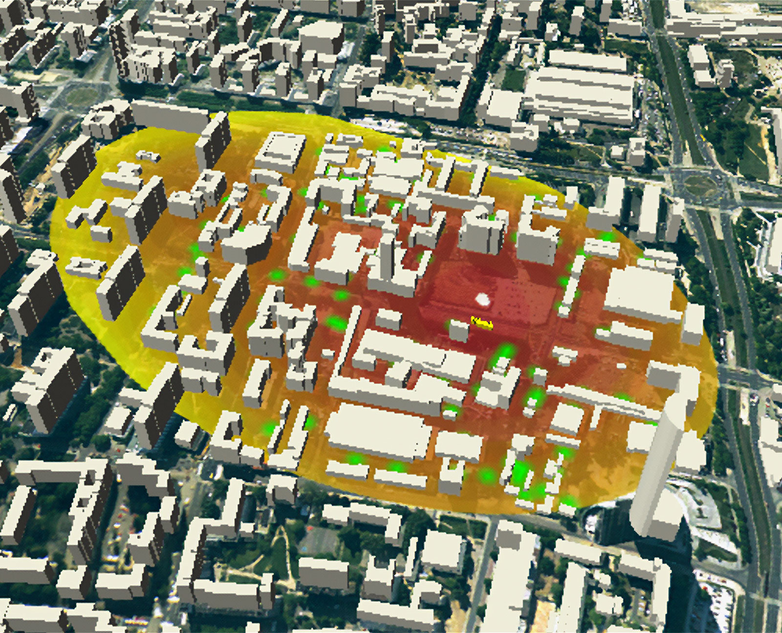
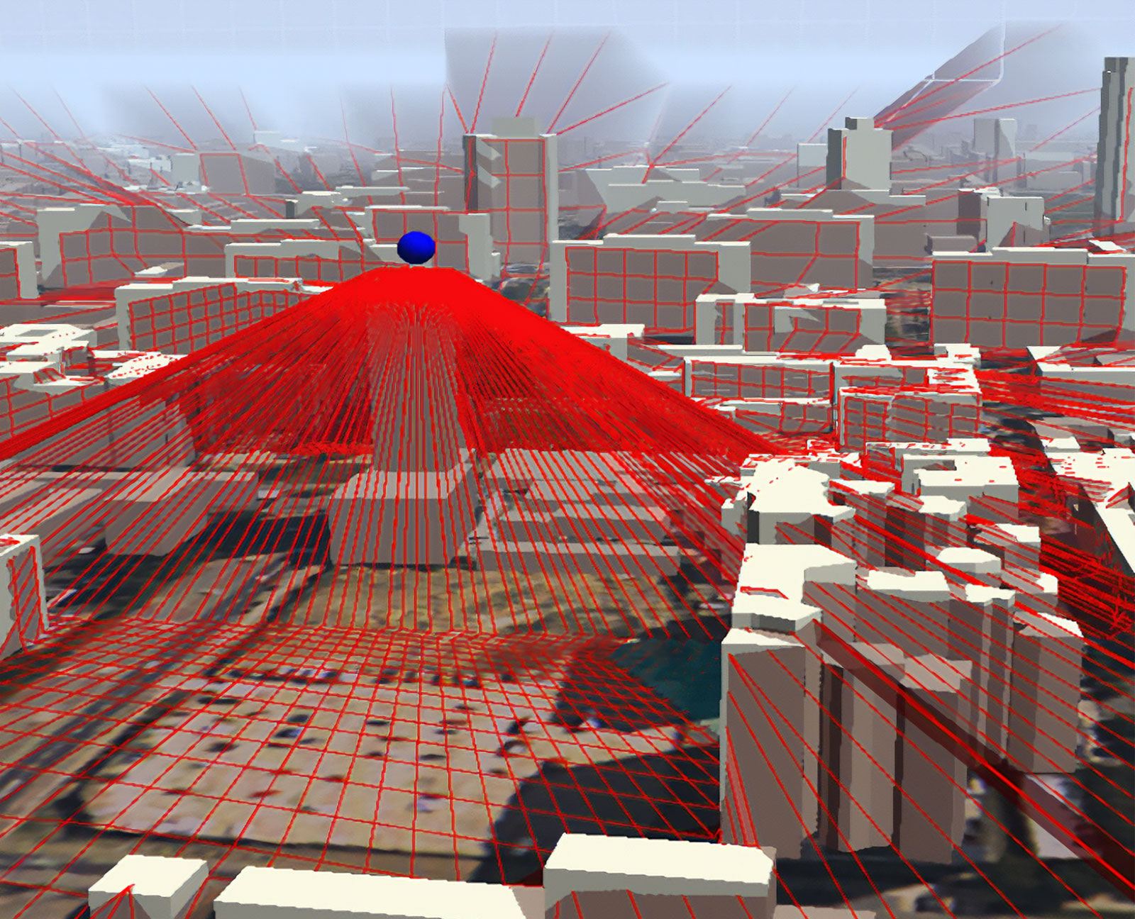
Platform for the aggregation, processing and analysis of urban and regional planning data Plan4Business (2014): the aim of the project was to develop a platform that can serve users as a catalog of planning data such as transport infrastructure, regional plans, city plans and spatial development plans. It not only provides a central access point to integrated, harmonized and ready-to-use formatted data, but also offers rich data analysis and visualization functionality via an application programming interface (API) and an interactive web interface. One of the results of the P4B project was a platform created for investors, developers and real estate users, which provided information on the assessed business potential of the location. The research was conducted based on the so-called catchment analysis – analysis of market potential during a specific travel time (more info).
Satellite geoinformation for crisis management and coordination – GECCO (2015): a project financed by the European Space Agency creates a service platform for the integration, storage and analysis of spatial information related to crisis situations, obtained mainly using satellite data. Thanks to the use of the platform, harmonized data will be integrated into a coherent, uniform, constantly growing and updated data set describing the development of a dynamic crisis situation. This form of data enables a series of analyzes using situational awareness among entities directly involved in crisis management, as well as the general public. The GECCO platform integrates information from Earth observation satellite systems and GNSS monitoring. This approach allows you to determine the impact of crisis events on road traffic.
EO4EP – Earth Observation for Eastern Partnership (2016-2018): the aim of the project was to achieve a dramatic increase in the use of satellite environmental information in development programs implemented by the World Bank and the European Investment Bank in the Eastern European region, in particular to support technical cooperation and knowledge exchange between the Eastern Partnership countries. Project financed by European Space Agency w ramach Earth Observation for Eastern Partnership. .